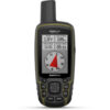
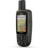
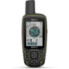
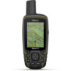
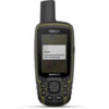
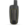
EA, Your outdoor adventures, whether in the backcountry or a big city, will be safer and more enjoyable with the Garmin GPSMAP 65s Handheld Navigator. This feature-rich device employs five global navigation satellite systems—GPS, GLONASS, Galileo, QZSS, and IRNSS—for pinpoint positioning, even in heavy cover, mountainous terrain, or urban canyons. The built-in altimeter, barometer, and three-axis electronic compass will aid and inform your travels. The navigator comes pre-loaded with routable topo maps of the U.S. and Canada, and has a microSD card slot for uploading finely detailed Garmin Topo 24K or HuntView Plus maps. It provides access to automatic geocaching updates from from Geocaching Live, including descriptions, logs, and hints. Emails, texts, and alerts are displayed when the GPSMAP 65 is linked with a compatible smartphone or device. You can use the device to plan, review, and sync your travels via the Garmin Explore app and website.
Your maps and notifications are displayed on a color, sunlight-readable 2.6″ screen. Built for the rigors of the outdoor life, the GPSMAP 65 is IPX7-rated waterproof, and will run for up to 16 hours on two AA batteries (NiMH or lithium recommended). It measures 6.3 x 2.4 x 1.4″ and weighs 7.7 ounces with the batteries.